Geospatial analysis
What is a geospatial analysis?
What is geospatial analytics
-
Spatial data
-
On-street imagery
-
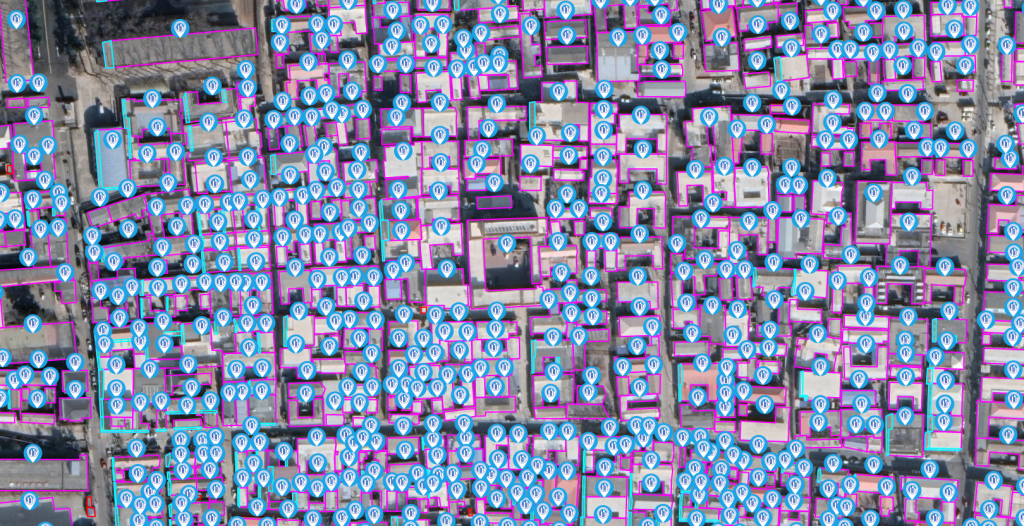
Aerial survey imagery
-
High-resolution satellite imagery
-
Multispectral imagery
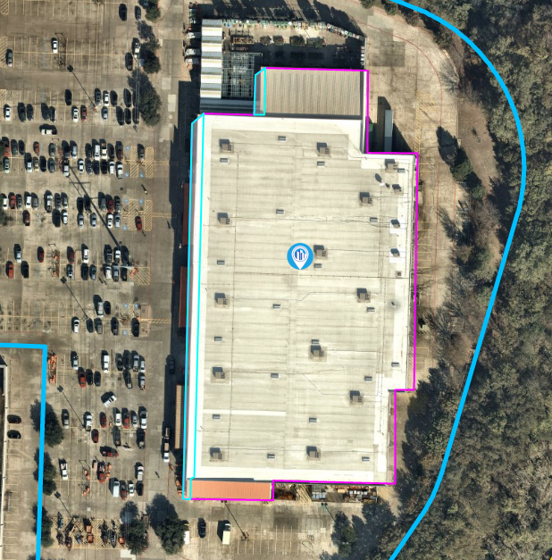
This data is then combined with other external data, like public sales records and land valuations, and processed with an AI algorithm to create a structured data set of building materials, risk assessments, loss control tools and much more.
In its absolute essence, geospatial analysis is simply a modern-age form of surveying or cartography.
Why geospatial data is essential for commercial insurance
Accurate data on a property has always been challenging to collect. In the past, insurers, and realtors needed to conduct on-site inspections to assess the state of a property. As technology progressed, insurers could leverage public data, previous property appraisals, and databases built on public record aggregations.
For insurers, it’s easy to see how such processes and databases can easily be tainted with incomplete, out-of-date, or even false information. Acting upon such data means that insurers and underwriters create policies and premiums that don’t truly reflect the value of the property that’s being covered.
Geospatial data is a revolutionary step in solving this problem.
Modern geospatial analytics provides more data points for you to act upon. For example, vegetation plays a significant role in creating an insurance policy for a commercial property. A facility that’s in a high fire danger area becomes more of a risk with overhanging vegetation. What’s more, that vegetation is always in a state of change, growing and being cut back. So modern, up-to-date data about the current environment is paramount for underwriters.
Other elements, such as property size, facade material, roof pitch and footprint area help insurers operate more effectively. That data then needs to be processed and presented in a way to help insurance professionals make better decisions.
Modern solutions like Tensorflight can provide this data for millions of commercial properties all over the world, delivered directly via API or web portal.

Who geospatial analytics can help
Here are several beneficiaries of geospatial analytics.
Underwriters
In the insurance industry, underwriters can take advantage of geospatial data and underwrite policies with more accuracy. Being able to access high-quality data associated with construction materials, and building type means that underwriters can create a more competitive insurance product.
Brokers
Geospatial analytics helps brokers to understand existing insurance policies on the market and offer a better product to their clients and insurers. Brokers are also able to create unique offerings and outperform their competitors.
Insurance claim officers
Claim officers are able to settle claims faster, thanks to the easy access to up-to-date imagery and data after an incident.
Loss control managers
Loss control managers are able to reduce the time and costs associated with on-site visits and inspections that are associated with measuring exposure and risk.
Technology platforms
Geospatial analysis gives users access to the data of millions of commercial properties. With Tensorflight, those properties can be anywhere in the world. Online platforms are able to connect to an API and rely on this data to create premium insurance tools to further those that can benefit from geospatial analysis.
Cost of poor risk assessment practice
It’s almost impossible to verify the data on a building without an accurate property location. In such situations, you need to trust that the broker, agent, or insurer gave you the correct and complete data. But that’s rarely the case as there may be reasons to omit specific data points.
A simple address or knowledge of the building location means you can look it up in public databases or question query providers. This process has many disadvantages.
It is more time-consuming, but there’s also the need to, once again, trust those that may not always be entirely honest.
What’s more, such data may have come from an analysis that happened many years ago. It’s now out of date, inconsistent with adjoining regions, and can’t be used to compare regions with more up-to-date data accurately.
Not relying on the data provided by geospatial analysis means you’re in the blind about potential property risks that may intentionally or unintentionally not be communicated.
Benefits of using geospatial analytics for risk assessment
As you can easily see, there are a host of benefits to using geospatial analytics. The most important takeaways for insurers include:
- Creating risk assessments and underwriting processes based on more accurate data, thus delivering a more precise property assessment and policy quote.
- Creating more accurate quotes significantly faster, thus improving the customer’s experience and ultimately their retention and satisfaction.
- Empowering salespeople to help customers find the best possible solution to their problem, thus nurturing and building a better relationship between customer and insurer.
- Being able to identify new risks, thanks to the highly-structured nature of geospatial data.
Using Tensorflight
The problems mentioned above are quickly, easily, and accurately solved using geospatial analysis. Finding a provider of such a vast amount of up-to-date data is paramount.
When you use Tensorflight to query the building, the information you receive is limited only by the amount of imagery we can access. Our platform has access to over 95% of the properties in your portfolio and can help you understand them better than any traditional query ever could.
Tensorflight has comprehensive coverage of millions of properties in North America, Europe, Great Britain, Australia and South East Asia making it a truly global platform.
Fresh data from your Tensorflight query will be accurate, with past data also available, making it easy for you to see how your asset has changed over time. Changes to your property from as little as six months ago will be reflected, empowering you to make a more educated and informed decision.
This information is easily connected to your databases via API or a dedicated web portal. Now, data that’s as rich as an inspector visiting the property can be available at your fingertips in seconds, no matter where you are in the world in relation to the property you’re looking at.
Conclusion
Incomplete, outdated, or inaccurate data does more harm than good to your business. Geospatial analytics provides you with a wide range of data points, but only quality data can be the foundation of your decision-making process. Geospatial imagery and data supplied by Tensorflight help you make more accurate data-backed decisions to create better products.